De Vuurberg
Gavdos Island © A. van Roekel
Home Milieu & Energie Gezondheid & Wetenschap Duurzaam Bouwen
Geologie & Reizen Landbouw & Voeding Natuurbescherming Eilanden


GAVDOS, ITS LANDSCAPE & GEOLOGY


PAGE 3/6


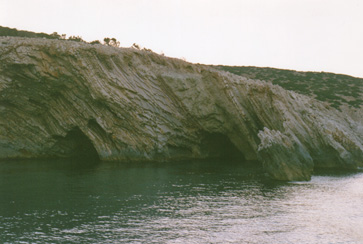
  Limestone (plattenkalk), Southeastern Coast © A. van Roekel
 

The island of Gavdos is 10 kilometres long and covers around 30 square kilometres. In the southeast, the limestone 'plattenkalk' is clearly visible from the sea. This type of sedimentary stone covers around 50 percent of the island (see the geological map). The southern part of Gavdos has steep cliffs, going almost vertically down a few hundred metres. The highest point on Gavdos is 384 metres.


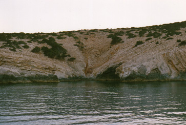
  Limestone (plattenkalk), Southeastern Coast © A. van Roekel
 

Over thousands of years, rainwater and rivers have eroded the soft limestone, creating valleys towards the sea. Although most of the useful rainwater went straight into the sea, the islanders used to store rainwater in underground reservoirs by catching the water on the limestone plateaus near their houses. Nowadays, after experimental drilling, groundwater is used to meet the growing demand of inhabitants and tourists in the summer months.

Next page

© Annemieke van Roekel, 2007.
Laatste wijziging: 14 juni 2013